Each land plot receives its own code upon registration.
This code is unique and is called a cadastral number (CN), which is assigned to any property for the purpose of its further identification .
Knowing this code, you can prove ownership and find out legal information about the object.
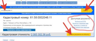
A cadastral number is a unique combination of numbers assigned to each unit of real estate when maintaining cadastral and technical records.
These concepts are regulated by the Law of the Russian Federation of July 24, 2007 No. 221-FZ “On the State Real Estate Cadastre”.
The order of the Ministry of Economic Development of the Russian Federation “On approval of the procedure for cadastral division of the territory of the Russian Federation and the procedure for assigning cadastral numbers to real estate objects” states that the cadastral number of a plot of land (ZU) is a set of numbers that are divided by colons into 4 groups for ease of visualization and use.
These numbers indicate the location of a specific memory :
- 1st group is the cadastre district
- 2nd group – cadastre region
- 3rd – quarter
- 4th – number of the specified section
For example, 77:01:0001010:33 means a land plot located in the city of Moscow on Nikolskaya Street.
How to find a plot by owner's name
It is impossible to determine the cadastral number of a land plot with only the owner's last name . The reason, first of all, is that in the region (country) where the land plot is located, persons with a similar surname may live. And the wider the search area, the higher the probability.
There are cases of coincidence not only of the last name, but also of the first and patronymic. Information can only be obtained at the site address .
The legislation also approved Law No. 152-FZ “On the processing of personal data of citizens.” Full name and details of personal documents cannot be made publicly available.
What documents confirm ownership?
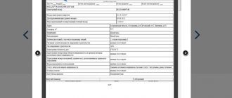
To find out this information, you need an extract from the Unified State Register for the area of interest. The official name is “an extract from the Unified State Register of Real Estate on the main characteristics and registered rights to the property.” In our case, a real estate object is a land plot.
In practice, situations often arise when the area of the plot indicated in the title document is smaller than it actually is. It is important to know that even in this case, Rosreestr authorities do not have the right to refuse state registration.
The indication of the area may indicate “Specified area”, this means that land surveying has been carried out. If “Declared area” is indicated, then land surveying still needs to be done.
In addition to the public map itself, other maps that have access to data updates via satellite surveillance will come to the rescue. For example, Google Maps. Through this map you can find out the actual real image of the area, find out whether there are buildings in certain areas.
However, tax officials are not always willing to help and provide the information of interest, so the interested party will have to submit a petition with detailed arguments for the need to obtain information about the owner.
This will help you decide in which zone to start searching, based on the purposes for which the site is needed. Thus, private individuals can only claim land for individual housing construction or agricultural land. Other categories cannot be transferred to private ownership. They can only be rented.
The attached document must be digitally signed by the applicant and a file signed with digital signature must be attached.
With all the punitive measures traditionally provided for in official documents by the currently used 1998 law “On gardening, gardening and dacha non-profit associations of citizens”, the concepts of deprivation of a plot are very vaguely spelled out in it.
This is important to know: How to organize SNT and get land
In these cases, privatization of a land plot requires additional time and financial costs. The process of registering property may be especially lengthy in the latter case. Initially, to register common property, it is necessary to make a decision at a general meeting of members of the society and submit the appropriate collective application to the territorial administration.
The territorial administration must, within 1 month from the date of filing the application, issue an order to provide the land into public ownership and approve the boundary plan. This order serves as the basis for further land surveying of both the common plot as a whole and each individual plot of land separately.
- Collection of documentation and its transfer;
- Waiting for the results of the decision made (the period during which the issue is considered and documents are studied is two weeks);
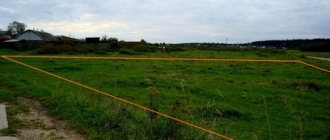
- If there is no cadastral plan, specialists must carry out a set of works related to visiting the land plot to specifically determine and fix the lines of its boundaries;
- Receiving a specific decision (if approved) that a land plot is being transferred to a citizen for personal use;
- Carrying out land surveying work, establishing boundary lines and creating a cadastral plan;
- Redirection of the prepared cadastral map by a specialist to a specific cadastre department;
- Concluding a specific transaction (for example, purchase/sale) or signing an agreement that the transfer of a land plot into the possession of a person is carried out without payment.
In the USRN extract
An identification number is assigned to each real estate property , the data of which is entered into the Unified State Register of Real Estate (USRN):
- when registering land plots in Rosreestr;
- when the Unified State Register includes data on the previously recorded property.
In most cases, the code that is assigned to a plot of land in the Unified State Register is needed by its owner. By requesting an extract from the Unified State Register of Real Estate, it is possible to obtain almost all legal information about the site :
- storage address;
- information about the owner;
- data on the encumbrances of the object;
- category of land to which the site is assigned;
- cadastral value of the land plot, which is taken into account when calculating the amount of land tax;
- storage area.
All other information about the land plot is not available to outsiders . Information can only be obtained upon receipt of a request from judicial or law enforcement authorities.
There are three ways to obtain an extract from the Unified State Register:
- contacting the local branch of Rosreestr;
- contacting the multifunctional center (MFC);
- or by requesting information through the government services portal.
To receive an extract in writing, you must submit an official application to Rosreestr or MFC. The request must include the exact location of the object for which data is required.
An extract from the Unified State Register is issued in writing, and its preparation usually takes about 4 working days .
When using an electronic request through the public services portal, the form is filled out on the website.
In the search window, enter the address of the land plot, its graphic coordinates, or conduct a search through the map.
The extract will be sent electronically and will be certified by a digital signature of a Rosreestr specialist.
Preparation of such an extract also does not exceed 4 days , but usually the data file is provided immediately on the day of the request.
Regardless of the form of citizens’ appeal, the USRN extract and the Public Cadastral Map reflect only reliable and up-to-date information for which government bodies are responsible.
How to find out the owner of a plot of land
Of course, being interested in who owns an apartment, house or land is your right, like any citizen of the Russian Federation. But such information cannot be provided to anyone, at least for security reasons for its owner. Therefore, if you want to know such information purely out of human curiosity, most likely they will refuse to provide it to you.
If the plot is part of undemarcated lands, it will not have a number and will not contain data in the Unified State Register.
Of course, a person selling a plot, when drawing up a purchase and sale agreement, will certainly use his title documents for the land. But what to do when the site is just being selected, or has already been selected, but the owner is unknown (for example, the site is abandoned).
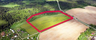
If the cadastral number of the plot is unknown, then it is possible, using the map, to find the desired plot of land. The public cadastral map shows all settlements and roads of various significance, including country roads.
The USRN information databases store data on the cadastre and rights to the object. In addition to many characteristics and information, the cadastral block contains a unique number, and the legal block reflects information about the owner of a specific land plot. Therefore, knowing its cadastral number, you can clarify the legal owner, his last name, first name and patronymic.
All of the following will be useful to you if you want to find out who owns the site, municipal or private.
Since the transaction does not undergo control by the Rosreestr authorities, you can only obtain information about the real manager of the real estate yourself, having received an extract from a government agency no earlier than 30 days before the conclusion of the transaction. Only in this case can we talk about the validity of the information specified in the document.
This is important to know: State act on land ownership
Any land plot has a legal owner, information about which can be obtained from the local district administration. If the site is not registered as a property, it belongs to the local municipality.
Rosreestr sends an extract within 3 working days (there are delays). If you want to get information faster, I recommend the Ktotam.pro service, which sends a ready-made statement within an hour. The cost is the same - 250 rubles, the official data is from the Unified State Register of RosReestr and is confirmed by the registrar’s electronic digital signature (EDS).
Contacting the MFC is similar to the previous one, since such centers are intermediaries between citizens and government agencies. The processing time for the request in this case may increase by 2 business days, which is due to the transfer of papers to Rosreestr and receipt of a response.
Registration of land ownership is completed by assigning a cadastral number to the plot - a location or index, which will be entered into the database and in the future will significantly simplify the search for the plot of interest on the cadastral plan. A passport will also be issued and a plan of the land plot will be drawn up, land surveying and alienation from the local municipality will be carried out.
A plot of land is a piece of real estate, and any real estate always has an owner. The land becomes property after the procedure of state registration of rights.
If the land is not owned or leased, then it belongs to the municipality. In addition, during the process of land registration, a land surveying procedure is necessarily carried out, information about which is provided to the district administration. By contacting the municipal property department with a request, you can also obtain the information you are interested in.
An extract request will be automatically generated and will also be assigned a number and password by which you can track the status of the request. True, in this organization you can only obtain information about who intended to register the land. However, the likelihood that the specified citizen completed the registration and became the owner of the land you are interested in is high.
All owned real estate is subject to land tax, so it is quite possible to contact the Federal Tax Service to obtain information. All information about the owner is transferred to the tax authorities within ten days from the moment the land is registered in the cadastral register to monitor stable tax payments.
This is where interested parties must submit requests, filling them out in accordance with the approved form. An extract and general data from the cadastral passport, if the application is satisfied, will be issued within a week, although for extended extracts there is a ten-day processing period for applications.
There are many reasons why information about a particular plot of land may be required. The most common case is that you notice a plot of land that is ideal for building a summer house or house, and you would like to purchase it.
You can order an extract in the following ways:
- at a branch of Rosreestr;
- multifunctional center;
- on the Public Services Portal;
- on the official website of Rosreestr.
How to find out who the owner of a land plot is online
This is the only institution that provides the most accurate information about all owners of real estate that has been registered since 1997. If the land is not owned or leased, then it belongs to the municipality. In addition, during the process of land registration, a land surveying procedure is necessarily carried out, information about which is provided to the district administration. By contacting the municipal property department with a request, you can also obtain the information you are interested in.
If a plot of land has not been transferred into ownership or lease to anyone, it means that the land belongs to the municipality.
Who owns the land? How can you find out if you don’t have any rights to it? You have your eye on a plot for a dacha, but you can see the ruins of an old house on it. This article describes where to find out whether a land plot is free, how to obtain information about the owner of the land and to whom it can be issued.
Subscribe to our channel in Yandex.Zen! Subscribe to the channel Registration of property rights is a rather labor-intensive process.
The most common document in our country confirming the right to own a plot of land is a certificate.
But in some localities, where the government takes a responsible approach to its task, vacant land holdings can be demarcated and registered in the cadastral register.
To protect your property and get full rights, you need to register your plot of land with Rosreestr.
Thus, if a plot is registered and has an owner, this information is stored in a fairly large number of authorities.
In this case, an obligatory point is to indicate the purpose of such an appeal. The most effective would be to specify as a goal “the need to verify ownership of real estate in order to ensure transparency in the acquisition of real estate.”
At the moment, it is Rosreestr that is the state registration center for a unified record of land, cartography and cadastre, where they issue a cadastral passport, draw up a cadastral plan and determine boundaries (demarcation).
This is important to know: Rules for landscaping the territory of St. Petersburg according to Resolution 961
You can also obtain information about a land plot from the tax office. To do this, you should apply for information about the owner of the property with the indicated cadastral number.
How to find out which real estate objects are located on a land plot
For example, you need information about a specific object in relation to which only its address is known, or you visually know the location of the property. The specified data is already sufficient to gain access to the rest of the information about the object. The official website of Rosreestr contains a public map of the territory of our state, the information of which any person has the right to view: citizen, organization, government or commercial service. The map is in the public domain.
We recommend reading: Duration of vacation of the Russian Federation Labor Code
Law Club Conference
The cadastral plan of the territory is provided in the form of an extract from the State Real Estate Cadastre within the boundaries of one cadastral quarter. The procedure for its provision is determined on the basis of Order of the Ministry of Justice of the Russian Federation No. 66 dated March 19, 2008 “On approval of forms of cadastral extract of a land plot and cadastral plan of the territory.” At the same time, the cadastral plan of the territory is a source of publicly available information and can be provided by the cadastral registration authority at the request of any person. An extract from the cadastral plan of the territory can be obtained both in paper form and electronically. The most efficient of them is the electronic version of the statement, which includes the following files:
We recommend reading: Will notary at your place of residence