What does it mean and what is it for?
The cadastral number of a land plot is an identification code that is assigned to an object when it is registered in Rosreestr. It is necessary to obtain information about land and carry out any legal actions with real estate. The site code is unique and remains unchanged for the entire period of the legal existence of the object.
The assignment of cadastral numbers to land plots made it possible to consolidate all data about them into a single cadastral database, where they remain until the moment when, for some reason, they are deregistered. Using the identification code, you can find out various data about the object:
- address;
- status;
- appointment;
- size and area;
- land plan;
- location, boundaries and coordinates;
- category;
- permitted use;
- cadastral value.
It is discussed in this material whether it is possible to find out and obtain a situational plan of a land plot using the cadastral number, and here you will find out whether it is possible, knowing the cadastral number, to determine the owner of the land plot.
Decoding the cadastral number of a land plot
It is worth noting that increasing the number of characters designating a cadastral district is unacceptable, since its designation is always identical to the region code. The cadastral number of a land plot is a unique code that allows you to obtain the most detailed information about the property
.
The land reform carried out in Russia with the release of the Land Code in 2001 made it possible to systematize information about plots that are not only owned by the state and municipalities, but began to pass into the private hands of enterprises and citizens.
The most common situation is not real estate transactions, but disputes with neighbors. If the landowner does not appear on his plot for a long time, perhaps it has not been improved at all, then the neighbors, as a rule, try to “take away” a piece of land unnoticed.
In what documents is the KN ZU indicated?
The digital code of the object is indicated in the following documents:
- cadastral passport for the land plot;
- title documents for land;
- in the boundary or cadastral plan.
The number is also prescribed when concluding contracts:
- purchase and sale;
- donations;
- inheritance;
- long-term lease;
- alienation of property, etc.
Important! All these transactions require registration with Rosreestr, which means the property must have an identification number.
The digital code of the land plot, if you have an actual address, can be found on the Rosreestr website using the “Public Cadastral Map”.
What it consists of: format
The identification code consists of a set of numbers combined into blocks in a certain order.
On average, there are numbers consisting of 13 digits, but there can be more or less of them, up to a maximum of 16 digits. Blocks are separated from each other by colons and may contain spaces.
Code format: AA:BB:SSMMTT:KK.
How to decipher: the meaning of digital blocks
Each block of numbers has its own meaning.
- AA – cadastral district. The territory of Russia is divided into 91 districts, which are assigned two-digit numbers. The first block contains information about the region or area where this site is located.
- ВВ – cadastral region. Their number differs in each district, and they also have two-digit designations.
- SSMMTT – cadastral quarter. These numbers indicate small settlements, city districts, etc. Depending on the area of the district, the block consists of 6 or 7 characters.
- KK – land allotment number. It is assigned by Rosreestr employees when registering an object. Depending on the number of plots located in the territory of the block, it contains one or more numbers.
Example: decryption of the number 02:09:010201:01.
- 02 – region of the Russian Federation – Republic of Bashkortostan;
- 09 – administrative-territorial unit – Belebeevsky district;
- 010201 – settlement – Annovka village, Sovetskaya street, house 65;
- 01 – number assigned to the site in Rosreestr.
Below is a video about the cadastral number of a land plot:
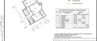
Below you will see what the cadastral number of a land plot looks like on a cadastral plan:
What is the cadastral number of a property
According to the law, obtaining a cadastral number is a mandatory procedure for the following categories of objects:
- residential premises (houses, apartments, rooms in communal apartments and dormitories);
- non-residential property;
- Earth.
The meaning of the single code will only change under the following circumstances:
- shared division of premises (each share receives its own address and is recognized as separate housing);
- combining several properties into one property.
Decoding the cadastral number allows you to get acquainted with a detailed description of the property, as well as its characteristics, these include:
- legal affiliation (private person, state, municipality);
- information about the current owner and former owners;
- the serial number assigned upon registration of the object;
- current property boundaries and structure;
- existing encumbrances (legal and financial).
The decoding of the cadastral number must correspond to the property passport, and you can get acquainted with a detailed description of the property by obtaining an extract from the Unified State Register of Real Estate.
A uniform format for cadastral numbers is in effect throughout the Russian Federation. This is an order of numbers located on one line, the values of which are separated by two dots. For example:
000:0000:0000:000
The first three indicators are universal and indicate the address of the property - region, district and quarter. Street names and house numbers are data that is not publicly accessible. The last digit is a serial number, which will be individual for each individual object.
Knowing the object number will allow you to find it on a public map and make it possible to clarify the boundaries of the site and its area. For more detailed information, you will have to request an extract from the unified state real estate register.
Information obtained through the cadastral number will allow you to check the legal purity of the property, as well as establish its detailed characteristics. You can find out the data:
- property owner;
- potential buyer of the property (if the sale of housing/land is planned);
- law enforcement agencies in the process of carrying out official activities.
Kinds
Cadastral numbers in the above format began to be issued to land plots in 2007. However, real estate registration was carried out before this time; digital designations were assigned to objects since 1992.
What does the conditional code do?
The old-style digital code differs in the number of blocks it consists of. In addition to information about the region, district, quarter and site code, data about the buildings located on the site was entered into the conditional number.
The code has the following format: AA:BB:SSMMTT:KK:N:R.
Since 2007, buildings have been registered separately in Rosreestr. To carry out any legal procedures with land, a cadastral number is required. This is due to the fact that conditional numbers were often given without carrying out a land surveying procedure, that is, the plots did not have precise boundaries.
What is temporary?
If the owner wishes to lease part of the land for a long-term lease, registration of the agreement with Rosreestr is required. The allocated area is assigned a temporary number, which will be valid until the end of the agreement, then it is cancelled. More details about the temporary statuses of memory are described in a special publication.
How to get it in Russia?
If cadastral work was not carried out in a timely manner and clear boundaries of the land plot were established, then it is quite possible that it does not have an identification number. In this case, you must contact the Rosreestr branch and register it, providing the following documents:
- identification;
- title documents for land;
- boundary plan drawn up by a certified cadastral engineer;
- technical plan;
- receipt of payment of state duty.
A package of documents can be provided:
- personally;
- through an authorized representative;
- via mail;
- by fax;
- online by filling out the appropriate form on the official website of Rosreestr.
The application review period is one month.
More information on how to check whether a land plot has been assigned a cadastral number and what to do if it is missing is described here.
Features of combining two memories into one
Attention! To expand the area of the plot, it is possible to combine several plots into one.
Features of the event:
- Only adjacent territories that have a common border can be united;
- It is necessary to draw up a boundary plan;
- lands belonging to citizens by right of legal ownership are united;
- the presence of only one owner when using land on a free or perpetual basis;
- the plots must belong to the same category;
- allotments must be located in the same territorial entity;
- all sites must have state registration.
To carry out the procedure you need:
- submit an application for the consolidation of land plots to the Rosreestr branch;
- obtaining a boundary plan from a cadastral engineer;
- transfer of new data to Rosreestr;
- receiving a new code.
Important! If there are several owners, a common shared ownership is formed.
Doubling
Since until 2013, real estate registration did not take place in a single database, cases of duplicate cadastral numbers are possible. This happens because data is entered into the state cadastre in two ways:
- registration of land plots in the prescribed manner in Rosreestr;
- supplementing the unified database with information about previously registered objects.
Therefore, it is possible to assign two numbers to one plot. In any case, this is the result of an error by Rosreestr employees. To clarify the data, you should make an extract from the Unified State Register. If an error is detected, you will need to contact the Rosreestr office with a request to correct the data. If there is a refusal, you need to send a statement of claim to the judicial authorities.
What to do if two numbers are registered for one memory
Sometimes it happens that when viewing your plot on a public cadastral map, two or more cadastral numbers are indicated for the same plot.
In most cases, this is the result of a technical error by Rosreestr employees .
It is recommended to make an extract from the Unified State Register, which should contain more accurate data.
You should also submit an application to correct the cadastral error.
How to do this is described in detail in a separate article.
How can I change and cancel this ID?
According to clause 3 of Article 16 of Federal Law No. 221-FZ, changing and canceling numbers is possible in the following cases:
- changing the address of the object;
- After land surveying, the boundaries of the territory changed;
- there was a merger of plots or, conversely, a division of land into several territories.
To obtain a new identification number, you should contact the Rosreestr branch or the MFC office. It is possible to enter new information into the State Tax Code without changing the number, for example:
- increase or decrease in cadastral value (read how often such a change in cadastral value can occur here);
- the emergence of new buildings;
- imposition of encumbrances, etc. (more information about the imposition of encumbrances and seizures of land plots by cadastral number can be found in this material).
Reference. If the number is changed, the old one is canceled and is no longer used.
Rosreestr employees have the right to forcibly cancel a cadastral number. This occurs in cases where the property was registered, but the owner did not register ownership of it within the prescribed period of five years. In the future, the citizen will have to either re-register the object or restore the old code in court.
The cadastral number of a land plot is a unique code assigned to a given object during state registration. It consists of four digital blocks and clearly identifies the location of real estate in the Russian Federation. The number is necessary when carrying out any legal procedures with property and allows you to obtain all the necessary information about the property.
Change
The need to change the cadastral number arises in cases where there have been any significant changes concerning the land plot.
For example:
- the site has changed its physical address;
- the boundaries of the allotment were changed during land surveying;
- The land plot was merged with other plots;
- the land plot was divided into several smaller plots.
The old number is canceled and is no longer considered valid.
Also, cancellation of the cadastral number of a land plot can be carried out on the initiative of local authorities , if within 5 years after registration with Rosreestr and assignment of the number, the rights to own the land have not been legally formalized.
To change the cadastral number, you should contact the Rosreestr branch at your place of residence, or the multifunctional center (MFC).
The following list of documents
is required :
- Landowner's ID;
- Certificate of ownership of the land plot;
- Land survey and cadastral plan;
- Cadastral passport;
- For buildings erected on the site, a technical plan is needed;
- Extract from the Unified State Register of Real Estate about the property;
- A document confirming the consent of municipal authorities to replace the CN.
Next, at the Rosreestr branch you should fill out an application form, either on the spot or by purchasing a form in advance, which can be downloaded from this link.
There you should indicate :
- The name of the cadastral authority to which the application is submitted;
- The reason why the cadastral number must be changed;
- Information about the applicant;
- List of documents you provide;
- Method of notification of a number change (by mail, in person, or electronically);
- Agree with the processing of personal data;