Its main purpose is precise determination of the boundaries of the land plot.
Information about the boundaries of land ownership is subject to recording in Rosreestr when it is registered for cadastral registration.
If the boundaries of the site are changed, a repeat survey procedure may be required.
To carry out this operation, you should take care in advance to prepare a package of necessary documentation. This will prevent problems from arising during its implementation , and the cadastral engineer will be able to complete land surveying work as soon as possible.
Based on the results of the work, a boundary plan is drawn up. This document is necessary when registering ownership of real estate, for dividing or merging land, as well as in the event that the owner of the property requests information about the boundaries of its territory. Of course, it will also be needed when considering legal disputes arising over the site.
Regulatory acts
The rules for conducting the land surveying procedure and the list of documents required for this can be found by studying the following regulations at the federal level :
- Law “On the State Real Estate Cadastre” dated July 24, 2007 No. 221-FZ;
- Law “On Land Management” dated June 18, 2001 No. 78-FZ;
- Land Code of the Russian Federation;
- Law “On State Registration of Real Estate” dated July 13, 2015 No. 218-FZ.
Law “On the State Land Cadastre” No. 28-FZ of January 2, 2000, links to which can still often be found on the Internet, is currently not in force . It has no legal force, since it was canceled back in 2008.
Certain nuances not regulated by federal legislation may be contained in legal acts of regions of the Russian Federation and local laws of settlements and other municipalities.
What documents are needed to clarify boundaries?
To clarify the boundaries, the owner of the site will have to first prepare all the necessary documents. Here is a sample list of them.
Passport
It is necessary so that the identity of the owner of the land can be confirmed .
If his authorized representative acts on behalf of the landowner, representing the interests of the owner, then a representative passport will be needed.
In such a situation, you also need a document confirming his authority.
It is a power of attorney signed by the owner of the property and certified by a notary.
In addition to the originals, copies of passports and powers of attorney may also be required .
Proof of ownership
Title documents make it possible to verify that the citizen ordering the land survey is actually the owner of the site .
In accordance with the norms of Russian legislation, these include :
- land purchase and sale agreement (PLA). It will be needed if the land was purchased from another person;
- land donation agreement (if the owner of the land received it as a gift from a relative or any other person);
- a certificate confirming the fact of acceptance of the inheritance (in the case where a citizen became the owner of land ownership as a result of receiving an inheritance);
- if the plot was received for use from local authorities, it is necessary to present a resolution from the administration granting the applicant a land plot;
- certificate of registration of rights to a property (it is issued by Rosreestr when registering ownership of a plot).
What kind of document of ownership will be needed depends on the method of acquiring the land plot (with the exception of the certificate of state registration of land rights, it is needed in all cases).
Copying to the ground
A copy is a copy of part of the general plan of the settlement, which depicts the territory of the site to be surveyed and the neighboring lands immediately adjacent to it. In essence, this is a detailed plan of the land.
The copy can be made in color or be a black and white image.
Must be present:
- symbols;
- the scale to which the plan was implemented;
- surname and initials of the compiler, his signature;
- date of document production.
To obtain this document, you should contact the architectural department of the municipality on whose territory the land plot is located. It can also be certified by the local administration.
Currently, it can be ordered at the MFC at your place of residence. The finished document will be received within 3 days from the date of application . A photo sample of it is shown in the figure below.
Cadastral passport
It contains all the information about the site included in the State Real Estate Cadastre . Previously, a cadastral passport could be obtained at the Rosreestr branch at the place of residence or at the MFC. Now such a document is no longer issued, since it was abolished as of January 1, 2021 .
Now, instead of it, an extract from the Unified State Register is issued.
An application for its production should be submitted to the same institutions where it was previously possible to obtain a cadastral passport.
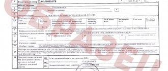
The extract from the USRN consists of several pages.
It includes the following information:
- data on the physical characteristics of the land plot: its area, land category, coordinates;
- graphic plan of the site;
- cadastral number of the object and the date of its assignment;
- cadastral value of the site;
- Full name of the owners or other persons who have the rights to use the property;
- information about the documents on the basis of which the land was acquired;
- date of registration of land ownership rights;
- restrictions or encumbrances under this lease (for example, mortgage or lease).
A sample statement can be found by going to
.
Owners of land plots who have issued cadastral passports for them before 2021 can still use these documents if necessary. Their effect remains in force if no legally significant changes have occurred to the real estate objects or documents on them.
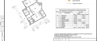
Cadastral plan of the territory
A cadastral plan is a drawing of the entire territory of the cadastral quarter in which the land is located. You can also get it from Rosreestr .
Now it can be ordered not only as a separate document. It is also possible to request an extended extract from the Unified State Register. It will include, among other things, this plan. A sample of it is shown below.
Branch of the Federal State Budgetary Institution "FKP Rosreestr" in the Rostov region
Conflicts between neighbors over land can be avoided only by determining the exact boundaries of adjacent plots. Without the consent of a neighbor, it is allowed to carry out the procedure by notifying him in an official way at least three times. The latest notification acquires the status of a signature of the owner of the neighboring territory.
This is interesting: If the amount of debt is not commensurate with the amount
Previously, the owners of such territories often had problems selling them or registering rights to them. Now the forest amnesty will simplify the procedure. The owner of the plot will not need to re-conduct land surveying (if it was carried out earlier) and contact Rosleskhoz for additional documents.
How to fill out an application correctly
To order land surveying work, you must write a corresponding application. The form of this application is not regulated in any way by law . Its text can be typed using a text editor on a computer or written by hand.
It must contain information necessary and sufficient for a correct understanding of its essence. should be no corrections, cross-outs, errors, typos or misprints .
The application must indicate :
- The name of the municipal body to which it is addressed.
- Information about the citizensubmitting an application for land surveying:
- FULL NAME.;
his passport details (series and number of civil passport, date and place of receipt);
- the address where this citizen lives.
- At the next stage, an indent is made down and the word “Statement” is written in the middle of the line.
- Next, it is necessary to formulate the request as clearly and accurately as possible, for the fulfillment of which this application is being written. In its content It is imperative to indicate the key characteristics of the site:
- its exact coordinates;
allotment area;
- the name of the document defining the citizen’s rights to land;
- indicate what rights the applicant has to it (location of the land plot in ownership, possession, use).
- It should be recorded that the applicant agrees to pay the cash costs associated with the survey work.
- The application must be certified by the signature of its originator. It also indicates the date it was written.
Example. To the Land Development Committee of the Kolomna District, Moscow Region. from Nikiforov Nikolai Petrovich, living at the address: Kolomna, st. Suvorova, 100, apt. 100. Passport data: series 2255, No. 123456, issued by the Kolomna Department of Internal Affairs on December 2, 1998.
Example. I ask you to carry out land surveying of the site located at the address: Moscow region, Kolomensky district, Semenovskoye village. Cadastral number: 43:16:0027371:000. Certificate of ownership: MM-74 No. 792027.
To download the application form, you can follow the link.
Documents for land surveying
- An identification document of the owner of the plot (passport) or, if the owner cannot order land surveying on his own, a passport and power of attorney of his representative, as well as copies thereof.
- Legal documents. Among them:
- Agreement for the purchase and sale of land (if it was acquired by purchase from another owner).
- Donation agreement (if the plot was donated to the owner by another person).
- Certificate of inheritance (if the land was received as an inheritance by law).
- Resolution of the administration of the subject of the federation on the provision of a plot of land to the customer (if it was transferred for use by the authorities).
- Certificate of state registration of rights (issued when the owner takes ownership of the property in the Rosreestr authorities).
- Documents that include data on the boundaries, size, geographical location and area of the site: cadastral extract from the register, cadastral plan, certificate from the BTI about the absence of buildings on the site or cadastral passport of the building, if available.
- Application for carrying out boundary work.
- Collection and study of all necessary data about the site, including verification of documents provided by the customer.
- Preparation of a land surveying project.
- Notification of persons whose interests may be affected when establishing boundaries, namely, owners of neighboring plots.
- A specialist will visit the site and determine the boundaries of the land plot, taking into account the actual area of use.
- Geodetic survey of a site, determining its coordinates using special tools.
- Accurate calculation of land area.
- Development of a site plan with all boundaries and coordinates.
- Making boundary work.
We recommend reading: Additional pension for military pensioners
Features of drawing up and sample power of attorney
If the owner of a land plot has instructed his representative to submit an application for land surveying, then he must issue a power of attorney for him and have it certified by a notary office .
The power of attorney must include the following information :
- the date of its preparation (without it, any power of attorney is void);
- Full name, date of birth and passport details of the owner of the land (series and passport number, where and when it was received);
- FULL NAME. and passport details of the person representing the interests of the owner of the site;
- there must be a phrase confirming that the representative has the authority to perform actions on behalf of the principal and represent his interests in the institutions of a particular settlement;
- to what extent the representative is vested with the powers delegated to him (an exhaustive list of specific powers defined by the principal can be given);
The power of attorney must also indicate:
- the exact location of the plot of land for which boundary work is required;
- it is advisable to indicate for what period the power of attorney is issued (in accordance with the provisions of Article 186 of the Civil Code of the Russian Federation, the period may not be indicated at all, then the power of attorney is considered valid for 1 year from the moment it begins to be valid);
- signature of the principal.
you can follow the link.
What is included in the agreement document
During the land surveying procedure, in accordance with the law, it is required to notify all interested parties about the establishment of the boundaries of the land plot.
Such persons are usually the neighbors of the site, whose lands are directly adjacent to it. They are required to obtain consent to determine the boundaries .
For this purpose, a separate document is drawn up - an act of approval; it includes comprehensive information about the boundaries of land ownership. The fact that this act was signed by neighbors on the land plot means that they do not have any claims related to the boundaries of the land plot.
This act is filled out by a cadastral engineer . You can apply for its registration at the local branch of Rosreestr.
This document consists of the following details :
- name of the act;
- location of the land plot to be surveyed;
- information about the main characteristics of the site relating to its territory (area, information about boundaries);
- cadastral number of the land plot;
- cadastral numbers of neighboring landholdings adjacent to the site;
- FULL NAME. the citizen who owns the property;
- if his representative acts on behalf of the copyright holder, his full name should be indicated. and power of attorney number;
- in what order the approval procedure was carried out (individually or at a general meeting);
- if any of the interested parties have objections, they should also be reflected in the act;
- signature and seal of the cadastral engineer who compiled the document;
- signatures of all persons interested in the results of determining the boundaries of the allotment.
If the owners of neighboring plots are properly notified about the drawing up of an approval act, the document is considered accepted, even if they refuse to sign it (if there are objections, a corresponding entry is made in the act, certified by the signature of the person who disagrees).
Here is an example of a completed approval document.
How to obtain and draw up consent from neighbors to build a house closer than three meters to the property line
As mentioned above, outbuildings should be located at a distance of 1 m from the border , but the bathhouse should be located at a distance of 8 meters from the fence . If you plan to build any of these objects in violation of building codes, you will have to enlist the support of your neighbors, who will formulate an agreement.
- it is allowed to use any form to compile it, but it is still recommended to view the sample indicated above;
- experts advise additionally contacting a notary to certify it, and this is considered especially important if a neighbor sells his property to another person in the future, and the new owner does not agree with the construction of an object next to his property;
- The consent must contain accurate and reliable information about the sites and the parties themselves so that they can be easily identified.
This is interesting: Indexation of Pensions for Working Pensioners in the Chernopils Coy Zone